LiDAR Mapping: Precision Data Collection for Various Industries
Learn how drone-based LiDAR mapping delivers accurate 3D data for various industries such as construction, infrastructure, and environmental projects.
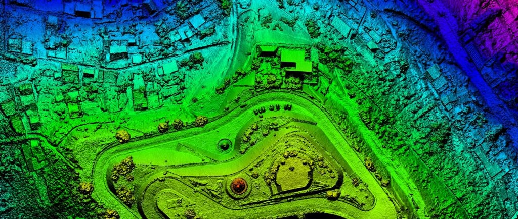
In industries where accuracy and precision are paramount, LiDAR (Light Detection and Ranging) technology is transforming how data is collected and analyzed. By sending out laser pulses and measuring the time it takes for them to bounce back, LiDAR creates detailed, high-resolution 3D models that reveal insights invisible to the naked eye. These models, often called point clouds, are indispensable in fields such as construction, environmental monitoring, and infrastructure inspection.
How LiDAR Mapping Works
LiDAR uses a system of sensors that emit thousands of laser pulses per second. These pulses hit surfaces—whether trees, buildings, or the ground—and return to the sensor, which calculates the distance based on the time it took for the pulse to return. This method produces a comprehensive map of the environment with millimeter-level accuracy, even in conditions where traditional imaging struggles, such as through dense vegetation or cloud cover.
By mounting LiDAR on drones, we can now capture data over large areas in a fraction of the time traditional methods take. This drone-based approach to LiDAR mapping is particularly valuable for industries requiring frequent or large-scale data collection over difficult terrains.
Examples of Automation in Action
1. Topographic Mapping for Construction
LiDAR-based topographic maps are highly detailed, offering accurate representations of land contours, slopes, and potential hazards, which are critical during site preparation and earthworks planning. By generating precise elevation data and 3D terrain models, LiDAR helps architects, engineers, and construction managers avoid costly errors in grading, excavation, and drainage design.
In land development projects, a developer might use LiDAR to analyze a potential site’s topography, enabling better-informed decisions about grading and drainage before construction begins. With the accuracy of LiDAR, developers can identify potential issues such as erosion risks or areas prone to water accumulation.
2. Infrastructure Inspection and Monitoring
For industries managing large-scale infrastructure such as pipelines, power lines, and transportation networks, LiDAR’s high-resolution scans are invaluable. LiDAR not only detects land shifts or signs of structural wear but also pinpoints vegetation encroachment or changes in land that could threaten the integrity of critical assets.
In a pipeline inspection project, LiDAR is deployed to capture data across vast areas, helping operators monitor for signs of subsidence, soil erosion, or vegetation growth, which could lead to costly leaks or failures if left unchecked.
3. Environmental Monitoring and Conservation
LiDAR’s ability to penetrate dense vegetation makes it ideal for forest management, coastal erosion studies, and wildlife habitat conservation. It provides an accurate view of terrain changes over time, enabling better decision-making in conservation efforts or monitoring the effects of climate change.
Forest management projects leverage LiDAR to assess canopy structure, biomass, and tree health. This allows for detailed resource planning and monitoring of forest regeneration or deforestation impacts.
4. Disaster Management and Urban Planning
With the increasing use of drones, LiDAR sensors have become smaller, more powerful, and more affordable. This opens the door for new applications in industries such as precision agriculture and autonomous vehicles, where real-time 3D data is crucial for operation. LiDAR data is now integrated with AI and machine learning models to provide predictive insights and real-time decision-making capabilities.
Advancements in LiDAR Technology
With the increasing use of drones, LiDAR sensors have become smaller, more powerful, and more affordable. This opens the door for new applications in industries such as precision agriculture and autonomous vehicles, where real-time 3D data is crucial for operation. LiDAR data is now integrated with AI and machine learning models to provide predictive insights and real-time decision-making capabilities.
Why Choose Lumex Productions for Your LiDAR Needs?
At Lumex Productions, we combine cutting-edge drone technology with high-precision LiDAR mapping services to deliver results tailored to the unique challenges of your industry. Whether you need 3D terrain modeling for a construction project or environmental data for land management, our team ensures the highest level of accuracy and detail in every scan.
Our LiDAR services include:
3D Terrain Mapping: Get precise topographic models for construction, land development, and environmental monitoring.
Infrastructure Inspection: Monitor pipelines, roads, and other critical infrastructure for land shifts, damage, or encroaching vegetation.
Environmental Data Collection: Capture comprehensive data on forest density, water flow, and land use to manage resources effectively.
LiDAR mapping is revolutionizing how industries collect and use data, offering unparalleled precision for everything from construction to environmental monitoring. At Lumex Productions, we leverage the latest in drone technology and LiDAR systems to provide detailed, actionable data that helps our clients work smarter, safer, and more efficiently.
With our drone-based LiDAR systems, you can capture data faster, more accurately, and at a fraction of the cost of traditional methods. Contact Lumex Productions today to see how we can help your business make smarter, data-driven decisions.With our advanced technology and expertise, Lumex Productions ensures seamless integration of AI and automated systems into your operations, delivering actionable insights and optimized performance. Ready to elevate your operations?
Lumex Productions
Setting new benchmarks in the industry with innovation, accuracy, and excellence.
Contact Us
469.444.7990
© 2026. All rights reserved.